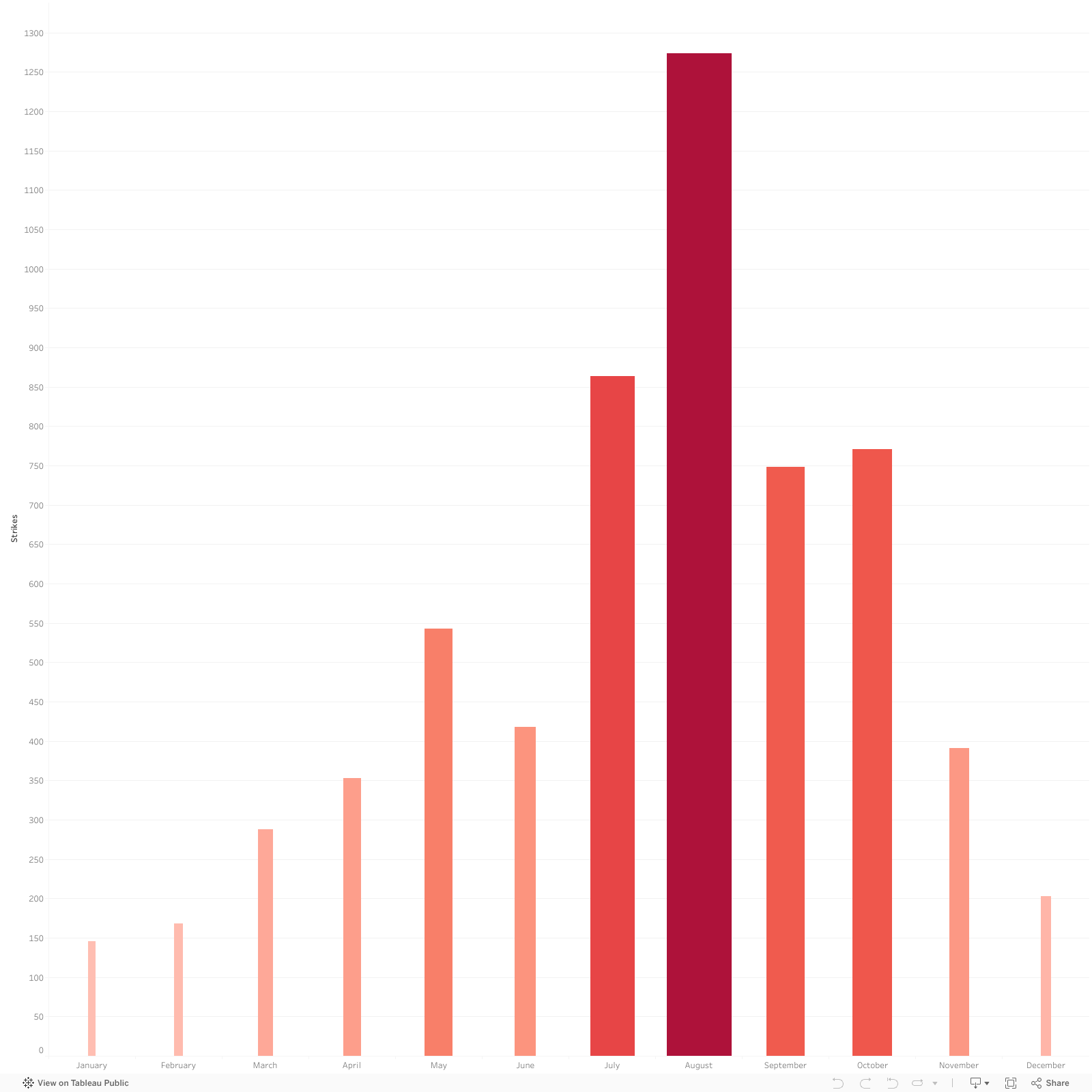
Animals Struck
Who Thinks They Can Beat a Plane?
While not every animal that is struck by a plan can be identified, there is an attempt to learn what speciese is killed as many times as possible. This is done in a variety of ways, some of which can be identified by sight, while others are sent off to the Smithsonian for identification. I was shocked to learn that no matter where in the United States a bird is struck its remains are always sent all the way to the Smithsonian. I did not learn why this is the case, as the dataset did not indicate a reason, merely that it was done, but I would be curious to learn when and why this practice started.
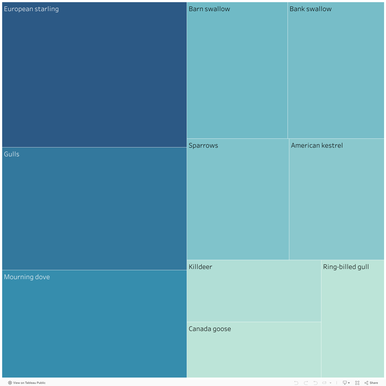
Top 10 Named Contenders
These are the top 10 idenfied animals, all are birds. The top two data points are actually unidentified small and medium, but I felt showing the top 10 named species would be more significant. To see the full list of both birds and mammals, click on the images below the visualization to see a table showing every species listed in order.
Here are the complete tables of all animals struck.
Birds
Despite their small size, many birds think why not!
| Animal Name | Challengers |
|---|---|
| Unknown bird - small | 1223 |
| Unknown bird - medium | 887 |
| European starling | 405 |
| Gulls | 343 |
| Mourning dove | 300 |
| Barn swallow | 208 |
| Unknown bird | 202 |
| Bank swallow | 199 |
| Sparrows | 187 |
| American kestrel | 174 |
| Killdeer | 126 |
| Canada goose | 113 |
| Ring-billed gull | 112 |
| Unknown bird - large | 103 |
| Tree swallow | 97 |
| Swallows | 96 |
| Blackbirds | 82 |
| Horned lark | 80 |
| Red-tailed hawk | 76 |
| Hawks | 71 |
| American robin | 55 |
| Rock pigeon | 52 |
| Eastern meadowlark | 48 |
| Chimney swift | 48 |
| Red-winged blackbird | 38 |
| Brown-headed cowbird | 38 |
| Ducks | 33 |
| Big brown bat | 24 |
| Geese | 23 |
| American crow | 21 |
| Mallard | 20 |
| Perching birds (y) | 20 |
| Great blue heron | 19 |
| Microbats | 19 |
| Cedar waxwing | 15 |
| Northern rough-winged swallow | 12 |
| Common grackle | 10 |
| Common nighthawk | 10 |
| Crows | 10 |
| Peregrine falcon | 10 |
| Turkey vulture | 9 |
| Bald eagle | 9 |
| Herring gull | 9 |
| Owls | 9 |
| Grasshopper sparrow | 8 |
| Osprey | 8 |
| Cliff swallow | 7 |
| Little brown bat | 7 |
| Ducks, geese, swans | 7 |
| Great horned owl | 7 |
| Swainson's thrush | 7 |
| Dark-eyed junco | 7 |
| Savannah sparrow | 7 |
| Eastern kingbird | 6 |
| Song sparrow | 6 |
| Sandpipers, curlews, phalaropes, allies | 6 |
| Short-eared owl | 6 |
| Wild turkey | 6 |
| Snowy owl | 6 |
| Finches | 6 |
| Northern flicker | 6 |
| Cooper's hawk | 6 |
| Unknown bird or bat | 6 |
| House sparrow | 6 |
| Common snapping turtle | 5 |
| Laughing gull | 5 |
| White-throated sparrow | 5 |
| Merlin | 5 |
| American goldfinch | 5 |
| Gray catbird | 4 |
| Wilson's snipe | 4 |
| Green-winged teal | 4 |
| Great egret | 4 |
| Foxes | 4 |
| Belted kingfisher | 4 |
| American golden-plover | 4 |
| Ovenbird | 4 |
| Northern mockingbird | 4 |
| Snow goose | 4 |
| Yellow-bellied sapsucker | 4 |
| Orioles | 3 |
| Eastern red bat | 3 |
| Upland sandpiper | 3 |
| Eastern bluebird | 3 |
| American coot | 3 |
| Semipalmated plover | 3 |
| Perching birds (z) | 3 |
| Hoary bat | 3 |
| Pectoral sandpiper | 3 |
| Wrens | 3 |
| Double-crested cormorant | 3 |
| Raptors: Hawks, eagles, vultures, kites, osprey, f | 3 |
| Common loon | 3 |
| Snow bunting | 2 |
| New World wood-warblers | 2 |
| Red-shouldered hawk | 2 |
| Yellow-bellied flycatcher | 2 |
| Pigeons | 2 |
| Unknown terrestrial mammal | 2 |
| Yellow-rumped warbler | 2 |
| Barn owl | 2 |
| House wren | 2 |
| Brown thrasher | 2 |
| Swamp sparrow | 2 |
| Wood duck | 2 |
| Ruby-crowned kinglet | 2 |
| Eastern cottontail | 2 |
| Starlings | 2 |
| Nashville warbler | 2 |
| House finch | 2 |
| Palm warbler | 2 |
| Vesper bats | 2 |
| Bonaparte's gull | 2 |
| American woodcock | 2 |
| Terns | 2 |
| Baltimore oriole | 2 |
| Bobolink | 2 |
| Least sandpiper | 2 |
| Eastern phoebe | 2 |
| Dunlin | 2 |
| Field sparrow | 2 |
| Brown pelican | 2 |
| Silver-haired bat | 2 |
| Hermit thrush | 2 |
| Great black-backed gull | 2 |
| Purple martin | 2 |
| American pipit | 2 |
| Northern harrier | 2 |
| New World Vultures | 1 |
| Tundra swan | 1 |
| Barred owl | 1 |
| Northern pintail | 1 |
| Blackpoll warbler | 1 |
| Chestnut-sided warbler | 1 |
| Cackling goose | 1 |
| Wood thrush | 1 |
| Ring-necked duck | 1 |
| Nelson's sparrow | 1 |
| Common yellowthroat | 1 |
| Black-capped chickadee | 1 |
| Pigeons, doves | 1 |
| Sharp-shinned hawk | 1 |
| American black duck | 1 |
| Red-eyed vireo | 1 |
| Sanderling | 1 |
| Painted turtle | 1 |
| Indigo bunting | 1 |
| Egrets | 1 |
| Black-bellied plover | 1 |
| Caspian tern | 1 |
| Semipalmated sandpiper | 1 |
| Vesper sparrow | 1 |
| Prairie falcon | 1 |
| American wigeon | 1 |
| Green heron | 1 |
| Yellow warbler | 1 |
| American tree sparrow | 1 |
| American redstart | 1 |
| Lesser yellowlegs | 1 |
| Ruddy duck | 1 |
| Rose-breasted grosbeak | 1 |
| Blackburnian warbler | 1 |
| Woodpeckers | 1 |
| Carolina wren | 1 |
| Cave swallow | 1 |
| Red-bellied woodpecker | 1 |
| Shorebirds | 1 |
| Fish crow | 1 |
| Chipping sparrow | 1 |
| Broad-winged hawk | 1 |
| Pond slider | 1 |
| Bats | 1 |
| Blue jay | 1 |
| Redhead | 1 |
Mammals
If we thought deer in headlights on a road was interesting...
| Animal Name | Challengers |
|---|---|
| White-tailed deer | 72 |
| Woodchuck | 25 |
| Red fox | 22 |
| Coyote | 12 |
| Striped skunk | 10 |
| Virginia opossum | 8 |
| Turtles | 5 |
| Raccoon | 4 |
| Eastern box turtle | 1 |
| Mink | 1 |